
×
![]()
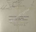
London & North Eastern Railway
Map of the Northern District, Scottish Area
Large LNER fold-out 1930s linen-backed map, scale 1/2 inch to 1 mile. Covers the lines east of Stirling between the Forth and the Tay, then north from Dundee to Montrose with the last station being Inverbervie. Unmarked blue card covers.


Available in Stock:
Contents Condition: Very Good
Cover Condition: Very Good
Condition terms defined
Condition terms defined
Format: Map
ISBN: ---
Pages: 0
Cover Type: Cloth Boards
Publisher: London & North Eastern Railway
Year: ---
Language: English
Edition: First
Size: Octavo (8vo)